Walkable City book applauds John Schneider for “single-handedly bringing streetcars to Cincinnati”


urt_Speck_Walkable-City_cover
[Graphic of book cover: CNU]

by Lyndon Henry

My Urban Rail Today colleague John Schneider is given some much-deserved kudos in Jeff Speck’s acclaimed book on urban livability and new urbanism, Walkable City: How Downtown Can Save America, One Step at a Time.

A review posted on the website of the Congress for the New Urbanism (CNU) describes Speck as ” a city planner who advocates for smart growth and sustainable design”; he’s also the author of Suburban Nation, depicted as a “landmark bestseller”.

“Bursting with sharp observations and real-world examples, giving key insight into what urban planners actually do and how places can and do change, Walkable City lays out a practical, necessary, and eminently achievable vision of how to make our normal American cities great again…” reports the review.

One of the “real-world examples”, cited on page 140 in a chapter titled “Let Transit Work”, is “John Schneider of Protransit, who is single-handedly bringing streetcars to Cincinnati, someone out there hunting down federal and state dollars, leading fact-finding junkets, and otherwise fighting the good fight for mass transit.” (Protransit is a Cincinnati-area group advocating rail transit alternatives for the city.)

John (known locally as “Mr. Streetcar”) declines credit for “hunting down federal and state dollars”, but he’s certainly forged new paths in terms of “leading fact-finding junkets” — through organizing enlightening trips, year after year, from Cincinnati, Ohio to Portland, Oregon, for groups of various regional civic officials and community leaders to visit Portland and inspect the metro area’s globally acclaimed rail transit systems first-hand. Those eye-opening excursions have clearly played a key role in persuading local community leaders (and similar participants from other communities) to back rail transit in Cincinnati and elsewhere — and represent a highly effective model for urban rail supporters to nurture local support in their own cities.

The CNU review includes excerpts from Speck’s book and a link for ordering a copy from Amazon.

So many urban rail projects — maybe this suggests success?


urt_usa-lrt-brt-rrt-New-Prj-2013_Transport-Politic
[Map: The Transport Politic]


by Lyndon Henry

Adversaries and critics of urban and regional rail projects often try to portray each new-start rail project in each city as some kind of an “outlier”, an isolated case of presumable folly that has failed almost everywhere. But factual evidence has a way of trumping deceptive propaganda.

The map above, from The Transport Politic blog this past January, illustrates the reality — a veritable avalanche of new urban and regional rail starts across the USA and Canada. Dozens of rail projects (and a few “bus rapid transit”) are listed in the article, tallying projects launching in 2013 or already under way, totaling over $64.3 billion in investment, with opening dates as far out as 2020.

This gives rail supporters a strong argument: Why would so many cities be launching new projects, and extending their existing systems, if rail were such a failure? On the contrary, it’s overwhelmingly more plausible to figure that it’s rail’s tremendous success that’s driving this huge expansion of rail transit — even in the face of Washington’s absurd, self-imposed, and recurrent budgetary crises.

City after city is finding that rail has expedited urban mobility, boosted transit performance (e.g., ridership, economic indicators, environmental factors), and bolstered the economy and livability of their communities.

Bottom line: Urban rail by and large is a huge success, and more and more cities are going for it. Let us help get your own city on board.

Yonah Freemark’s original article in The Transport Politic has links to virtually every project — well worth checking out:
Openings and Construction Starts Planned for 2013

Urban Mobility: Know Your Objective


urt_por-lrt-xxxx0437-20050515_lh
Portland: With the objective of repopulating the city’s older neighborhoods by making them more car-light, electric streetcars are helping to connect work, housing, entertainment, and recreation so that a personal motor vehicle is no longer needed. [Photo: L. Henry]

by John Schneider

Ask yourself: What problem do you want to solve? And is the problem worth solving, or able to be solved, given the resources available to your community?

It would be nice to rid your town of congested highways, but the truth is, as you convert motorists into transit riders, other motorists are quick to fill up the empty roadway, so you never really get ahead in this game. A broad regional system of frequent, car-competitive transit designed to eliminate highway congestion will be very expensive to build and operate.

If you are focused on improving mobility in a particular corridor because of increasing jobs or strong housing growth in the corridor, then you need to consider the level of transit service that’s appropriate. If most trips in the corridor are short ones, adding buses may serve to meet the demand. If trips are longer, and if there is steady demand for travel many hours a day, rail solutions may be more appropriate.

Much of the recent interest in transit technologies is associated with the repopulation of dense city neighborhoods. This is happening in two out of three regions in the U.S. — even if the core city as a whole is losing population. So if your objective is to repopulate older neighborhoods by making them more car-light, electric streetcars can connect work, housing, entertainment and recreation so that a car is no longer needed in these neighborhoods. The money saved can be redirected toward better housing, better health care or for a child’s education. This sort of turns the transit for mobility argument inside out: less mobility can often mean greater savings and greater prosperity.

Once your objective is clear, make sure it is in sync with the aspirations of your city’s political leadership and leading institutions. Show them how achieving your objective can make their jobs easier.

Finally, can your objective be achieved in other ways? This is a very important question to answer. Your critics will always be insisting that other solutions are better and cheaper! You need to be able to show them they are wrong.

Ft. Lauderdale streetcar project rides a Wave


ftl-lrt-stc-sim-stn-peds-2013x_Wave-Stc-dot-com
Simulation of streetcar line in downtown Ft. Lauderdale. [Graphic: WaveStreetcar.com]

Ft. Lauderdale, Florida — Strong top-level civic and political support is driving this south Florida city’s streetcar project, and it just took another major step forward when, on March 12th, Broward County — in a unanimous vote of the county commission — gave final approval for a 2.7-mile, $147 million central area streetcar project, locally branded The Wave.

As the Sun-Sentinel newspaper reported in a March 13th article, the electric streetcar system “initially will travel a small loop around the urban core.”

As the report goes on to notes, the starter line will be a 1.4-mile loop with an investment cost of $83 million. “Though many other agency approvals are still needed, the funding is lined up and the line is expected to be up and running by 2016…” says the paper.

Funding for this starter loop has been compiled from a variety of sources:

• Federal government — $18 million
• City of Fort Lauderdale — $10.5 million (in cash or land)
• State of Florida — $32 million
• Metropolitan Planning Organization — $8 million
• Private — $14 million (special assessment from property owners along the line)

According to the article, for its short initial route,

The streetcar will run from the Central Bus Terminal on Broward Boulevard, south on Brickell Avenue through the Riverfront complex, then east on Las Olas Boulevard.

At Southeast Third Avenue, the streetcar hangs a right and chugs south over the bridge, converting from overhead electrical lines to battery power.

Once over the bridge, the streetcar returns to electrical power via overhead lines, and heads east on Sixth Street, right past the County Courthouse.

At Andrews Avenue, the streetcar travels south a block in order to loop back around to Third Avenue and return to the bus terminal.

However, local officials are determined to expand the route to 2.7 miles — extending the route north to Sistrunk Boulevard, and south to 17th Street — but that will require $50 million in transit project funding from the federal government. Broward County has applied for a federal grant for that amount.

As the Sun-Sentinel notes, “When complete, the route will pass a lineup of major employment centers, many of them public employers — the school board, federal and county courts, county government, Fort Lauderdale City Hall and Broward Health Medical Center.”

ftl-lrt-stc-map-Wave-2013x_Wave-Stc-dot-com
In map above, dotted lines indicate route alternatives. [Map: WaveStreetcar.com]

While most of the line will receive electric power from an overhead contact system (OCS — a trolley wire), for a short segment on the Third Avenue bridge over the New River streetcars will operate with onboard battery power. This type of “offwire” capability gives designers the flexibility to address difficult problems in routing the OCS poles and wires, but it comes with drawbacks. For example, batteries may drain quickly when running an air-conditioned car, especially with a full passenger load.

Furthermore, the weight and cost of each car is increased, because of the battery and associated extra equipment. Thus, not only are rolling stock capital procurement costs typically increased, but there may be an operating cost penalty as cars must carry the additional battery weight and undergo a delay in transitioning between OCS and offwire running.

But these compromises, and the total costs, may be minuscule in comparison with the significant public benefits that these kinds of rail transit investments tend to bestow. As the Sun-Sentinel predicts,

The thousands of people who work downtown will be able to hop aboard and leave their cars in garages. Suburbanites with business at the county courthouse will be able to take a bus downtown, then connect to the modern rail. And those who remain in their cars will share the road with the stop-and-go streetcars.

“It’ll be a game changer…” said Broward Transit Director Tim Garling, whose background includes work in Portland, Oregon, “considered the model city for rail” according to the Sun-Sentinel. “Rail kind of uniquely attracts development…” he added. “We’ve seen this across the country.”

For more on this project, access to the original article:
The Wave streetcar system right on track for downtown Fort Lauderdale

Kansas City — Another new downtown streetcar project starts to take shape


urt_kc-lrt-stc-sim-sb-Main-19th-St-2012x_Dntn-Corr-AA
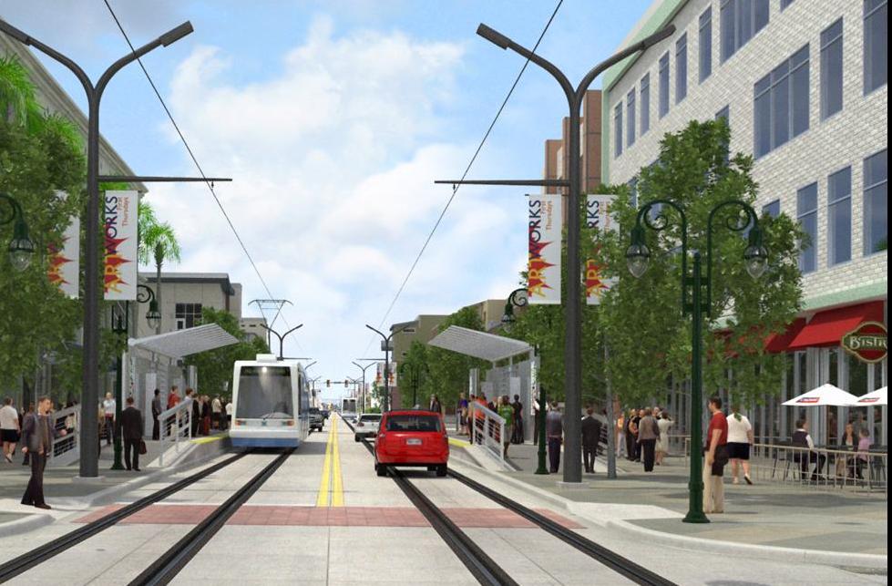
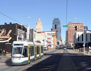
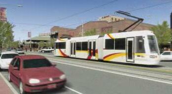
Simulation of streetcar southbound on Main St. at 19th St. [Graphic: Downtown Corridor Alternatives Analysis]

Kansas City, Missouri — At a March 6th public meeting, city planners presented details of their construction schedule for Kansas City’s proposed 2.2-mile, $102 million streetcar project, approved by voters in late December (2012). The details may be instructive for streetcar advocates in other cities, giving them an idea of what’s typically involved in this kind of project.

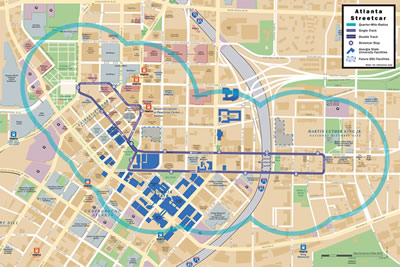
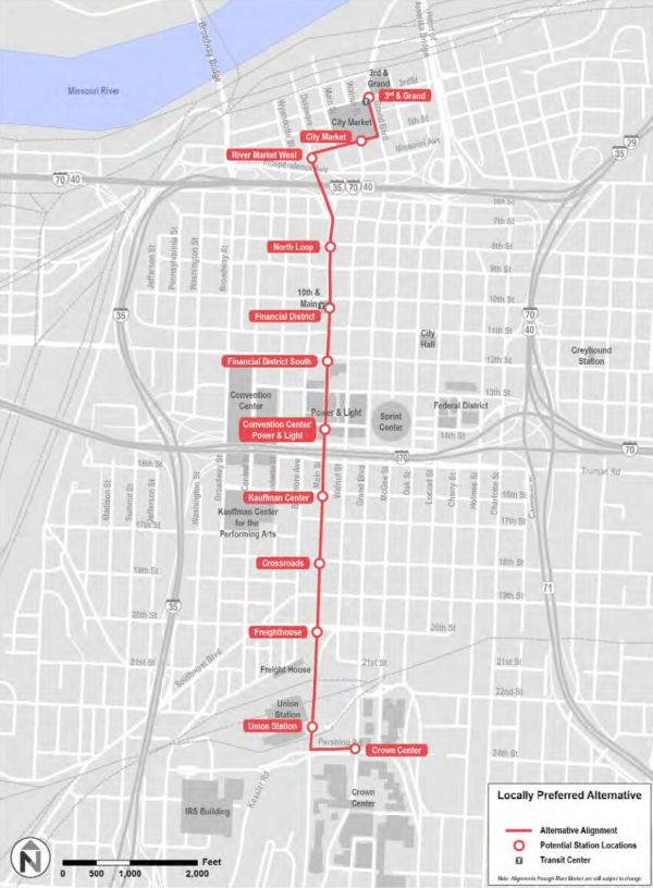
The line is planned to run through the city’s Central Business District from River Market to Union Station, also serving Crossroads and Crown Center. According to a Dec. 28th report in the Kansas City Business Journal, “Proponents of the plan say the line … will spur development along Main Street while helping to attract young, creative residents to the city’s urban core.” The system is currently projected to open for service in 2015.

urt_kc-lrt-stc-map-proposed-2012_Dntn-Nbhd-Assn-KC
[Map: Downtown Neighborhood Association of Kansas City]

Particularly for transit supporters in other cities considering a streetcar or large light rail transit (LRT) system, it’s instructive to look at the elements of this kind of project. A more recent report (March 7th) in the KC Business Journal provides an opportunity for this kind of examination, laying out the three main phases of the project.

At more than $46 million a mile, KC’s streetcar line will be far less costly than, say, a subway or monorail, or even many busways — but that per-mile price tag also buys a lot more than just the rail transit infrastructure, as we’ll see. First, let’s itemize the railway components themselves, some of which will occur over several of the phases:

• Streetcar rolling stock — to be selected, ordered, delivered.
• Tracks installation along Main Street from the River Market to Union Station.
• Rolling stock maintenance facility in the River Market to be designed.
• Underground utilities to be relocated.

That last item — relocating utilities — is not directly part of the rail infrastructure, but it’s a task that usually has to be done (although there are some ways to minimize or avoid it). In many cases, the utilities may have actually needed replacement for years, but the municipality or private utility owner holds off, hoping that the rail project will pick up the tab. There’s also wide divergence from city to city in terms of who the law specifies should be responsible for paying for such relocation — the agency sponsoring the rail project, or the utility owners.

Phase 1 (from 2013 until early 2014) will mainly focus on utility relocation and the construction of the maintenance facility. Utilities work will include:

• Opening trenches to remove and relocate utility lines.
• Suspending temporary overhead lines for temporary utility relocations.

According to the news report, this work will be done in three-block sections and taking two to eight weeks. “During the work, Kansas City residents can expect partial lane closings and temporary service interruptions.”

Work on the maintenance facility, lasting 12 to 18 months, will include:

• Clearing the site for the facility and starting construction of the building’s foundation.
• Commencing civil engineering work startup of actual shop construction.

Phase 2 (from late 2013 to late 2014) includes track installation (in pavement), station construction, and rebullding of streets and sidewalks. It’s debatable whether this last item, street and sidewalk reconstruction — routine for most urban rail projects — should be considered an indispensable component of the rail transit and assigned as a cost totally to the rail project.

To some extent, as with utilities, public works planners often realize that the streets and sidewalks need to be rebuilt anyway, and often wait to let the cost be picked up by the rail project. Also, these kinds of upgrades might be considered as more in the category of “urban amenities”, and some rail advocates argue they should be tallied separately as something like “urban renovation”.

On the other hand, it’s arguable that effective access to the new line requires good pedestrian facilities. Furthermore, for federal funding the Federal Transit Administration usually requires it (along with other amenities not directly essential to the transit operation, such as artwork at the stations).

In any case, both for track installation and the street/sidewalk reconstruction, the project schedule calls for closing “two city blocks … for three to four weeks to accommodate construction of the streetcar’s tracks and stops.” This will include:

• Removing existing pavement and sidewalks.
• Reconstructing sidewalks, curbs, and gutters.
• Installing railway hardware on track slabs with drainage facilities and special trackwork (switches, crossovers, etc.).
• Rebuilding existing curbs, gutters, and sidewalks near stations.
• Building concrete platforms and canopy foundations, and installing “amenities and finishes at the streetcar stops.”

As the Business Journal report indicates,

Construction of each station is expected to last three to four weeks. Track installation will require a 20- to 25-foot work zone and will close multiple lanes or entire sections of Main Street, depending on the width of the street at the work location.

Phase 3 (from late 2013 to late 2014), the final phase of construction, will focus mainly on the power system and traffic signals, with some replacement of street lighting (again, this last item may be one of those “urban amenity/renovation” elements not strictly essential to the urban rail project). There’s an advisory that “Temporary closures during non-peak hours are expected at each two-block section for the three to four weeks it will take to complete this phase of the work.” This last phase will include:

• Installing the overhead contact system (OCS) — i.e., the support poles and wiring for the electric propulsion system (this is often erroneously referred to as “catenary”, which is actually a somewhat heftier type of OCS; however, many streetcar lines and even some larger LRT lines use much simpler single-contact-wire OCS to minimize its visibility).
• Installing new traffic signals and street lighting (again, see the discussion above about “urban renovation” and whether the cost of these project elements should be assigned to the urban rail project).
• Installing power substations (these are just relatively small power booster units to maintain adequate voltage on the OCS, which tends to drop because of the resistance of the OCS wire).

“After construction is complete,” notes the Business Journal report, “the city expects to take four to six months for testing and startup work between late 2014 and early 2015.”

That, then, is what this relatively small KC urban rail project will involve. Hopefully, this information will be helpful to those of you contemplating similar projects for your own cities.

New Orleans — New streetcar project for North Rampart-St. Claude advances


no-her-stc-Canal-St-10041-20030917x_lh
Heritage-style streetcar on Canal St. [Photo: L. Henry]

New Orleans, Louisiana — Just a bit over a month since this city’s Regional Transit Authority (RTA) opened its brand-new Loyola streetcar line, the RTA has revved up its plans for yet another new line, this one along historic North Ramparts St. and St. Claude Avenue.

The new streetcar line would extend about 1.5 miles from busy Canal St. to Elysian Fields Ave. Originally the plan was to include a 1/2-mile spur down Elysian Fields, but evidently cost constraints have forced RTA to put the spur line on hold.

no-her-stc-map-Rampart-St-Claude-plan-2013-Mar-x_scrnshot-WWL-TV
Map of proposed N. Ramparts-St. Claude streetcar route. [Screenshot of WWL newscast]

no-her-stc-map-plan-Rampart-St-Claude-Elysian-Fields-20110125_RTA_Times-Picayune
Map of originally proposed N. Ramparts-St. Claude-Elysian fields line. [RTA and Times-Picayune]

The cost for the entire N. Ramparts-St. Claude-Elysian Fields project was estimated at $115 million in 2011, or about $121 million in 2013 dollars (roughly $45 million/mile).

New Orleans uses heritage-style streetcars on its system. The St. Charles line — oldest continually running car line in North America — runs original, historic 1920s-era Perley Thomas cars. Rolling stock on other lines, including the Canal and Loyola lines, are replica cars constructed by a partnership of RTA and Brookville Equipment Corporation.

Streetcars are broadly popular in New Orleans, and judging from a news report from WWL-TV, one could infer that there’s lots of support for the current extension project. Catherine Markel, owner of a wine store on St. Claude, emphasized that “revitalization of this corridor is important to me”, and she wouldn’t have opened her store unless she was sure the project was under way.

RTA bus riders interviewed by in the TV report also were enthusiastic. Bus commuter Altra Lindsey said that having another way to travel between the Lower 9th Ward and where she needs to go would be a beneficial addition to her daily commute.

“No one wants to stay here a long time waiting for the bus. If they had two forms of transportation things would move a long a little quicker…” Lindsey told the TV reporter.

More on this project, and the video report, are available at the original WWL link:

http://www.wwltv.com/news/North-Rampart-Saint-Claude-Avenue-Streetcar-Project-Moves-Forward-195789611.html

Atlanta Streetcar construction pushes forward


atl-lrt-stc-sim-narrow-str-2010_Atl-Stc-Prj
Simulation of Atlanta Streetcar on inner-city neighborhood street.

Atlanta, Georgia — Atlanta is another major U.S. city where streetcar mobility is making a comeback.

A recent article in Maria Saporta’s Saporta Report blog provides an update on the progress of the project. Quick summary: It’s several months behind, and about 5% over budget, mainly because of unforeseen problems with underground utilities. But the construction budget gap has been reduced from $10 million to about $5 million, and fingers are being crossed that that service will begin in the spring or early summer of 2014.

While the 2.62-mile streetcar project’s construction budget includes a financial buffer for contingencies — intended to offset exactly these kinds of cost overruns — and its enough to cover the current gap, says Saporta, “the project team does not want to use up all of its contingency budget in case other issues come up.”

Organized as a public-private partnership between the City, MARTA and the private Central Atlanta Progress/Atlanta Downtown Improvement District, the Atlanta Streetcar project is estimated to have a total cost of $92.7 million. Federal aid in the form of a $47.7 million TIGER II grant “gave the project life” says Saporta.

Based on Saporta’s tally, here’s a total budget breakdown for the project (millions):

• Federal TIGER grant — $47.7 million
• City of Atlanta — $15.6 million
• Atlanta Downtown Improvement District — $6 million

That adds up to an “initial net project total” of $69.3 million reports Saporta.

The rest of the budget includes:

• City of Atlanta — $9 million for streetcars (rolling stock)
• Department of Watershed Management — $8 million to move water and sewer utilities
• Livable Centers Initiative grant — $5.1 million for transit and pedestrian enhancements
• Another LCI grant — $1.25 million to convert Luckie Street into a two-way thoroughfare.

atl-lrt-stc-map-2013_Atl-Stc-Prj
Map of Atlanta Streetcar starter line route.

A.J. Robinson, president of Central Atlanta Progress, reports Saporta, emphasized how optimistic he was reharding the impact that the Atlanta Streetcar will have on Atlanta’s downtown. Already a number of new developments are being planned along the route.

“The building of the Atlanta Streetcar is the dawn of a new era for transit — one that can begin to transform the way we get around in our community” enthuses Saporta.

For more on the project, including a discussion of operating options, read the original article

Tucson — Streetcar project continues moving forward


tuc-lrt-stc-rend-x5-sideview-median-cars-2007_rta
Simulation of Tucson streetcar line. [Graphic: Regional Transportation Authority]

Tucson, Arizona — This medium-size city’s electric streetcar project continues to advance, according to a Jan. 14th report in the Arizona Daily Star.

While there’s still a lot of work to do, what’s left should be a whole lot less disruptive to traffic, businesses and neighborhoods, according to project manager Jesse Gutierrez.

Like all such projects using urban streets, Tucson’s streetcar construction has grappled with relatively ancient underground utilities, such as 100-year-old pipes in bad condition, as well as newer obstacles such as fiber optic cables. Nevertheless, according to Gutierrez and Tucson Transportation Director Daryl Cole, the construction schedule has been accelerated on some streets, including those near the Tucson Convention Center, to get heavy work finished before major events at the center coming in the next few weeks.

The article reports that most of the rail infrastructure is now in place. “There’s rail on the streets on the University of Arizona campus, University Boulevard, Fourth Avenue, parts of Congress Street and Granada Avenue.”

For more, read the article

[Streetcar simulation: Regional Transportation Authority]


Streetcar planned for another Washington, DC suburb


KONICA MINOLTA DIGITAL CAMERA
Inekon Trio streetcar for Washington’s new line.

The Washington, DC area already has streetcar plans — a line on H Street in the central city and along Columbia Pike connecting the Virginia suburbs of Arlington and Fairfax — and now there’s another suburban line on the planning table. According to a December 30th report in the Washington Post, “Arlington County is planning a 2.5-mile-long streetcar line along the Route 1 corridor between Crystal City and the Alexandria city limits.”

Serving what currently is “a high-rise, car-centric area” according to the article, the line is intended by planners to “help to create a walkable neighborhood with street-level retail, dense housing and offices.”

It’s all part of a nascent regional network of light-rail projects, which combined with existing Metrorail, VRE commuter rail, buses, car- and bicycle-sharing and pedestrian-friendly paths, would remake the urban landscape into distinctive destinations.

With an investment cost currently estimated at $146 million, the project would apparently be financed from a special commercial real estate tax plus tax increment financing (which would rely on future increases in real estate value to help fund for infrastructure improvements such as rail transit).

For more on this, see the original article.

wdc-lrt-stc-sim-str-2012_DC-Condo-Loft
Simulation of streetcar in street.